On my previous trip, I went to the Montserrat abbey by bike. That trip was part of a circular biking route I had found in a book, and which goes the whole way around Montserrat, starting and ending point being Marganell.
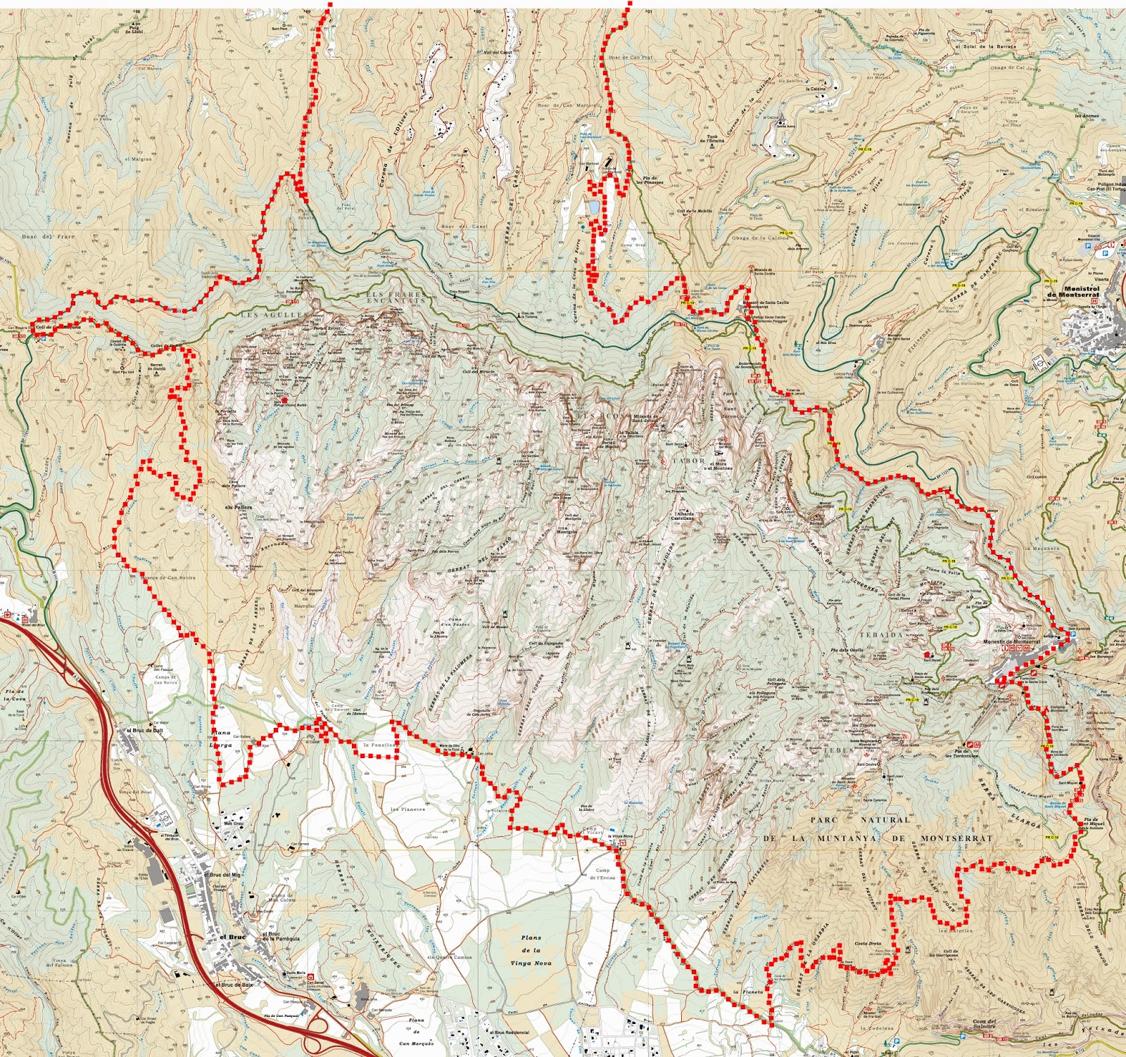 |
| Better part of the Montserrat round trip |
Last Saturday, Xavi and me decided to bike a little, and so it came, that I proposed the Montserrat round trip. Although the description marks it as hard, with only 40km it's not a very long trip. It's the up and downs of more than 1000m of accumulated positive altitude difference, that increase difficulty. Instead of carrying our bikes to Marganell by car, we started the trip from my village and so added some 12 km of distance and maybe 200m vertical meters.
The trip as a whole can be broken down into 3 different stages:
- Start to El Capítol
- El Capítol to Coll de Guirló
- Coll de Guirló to End
The first stage is uphill mostly and its highlight certainly is the arrival at the Montserrat abbey, always buzzing with activity and tourist attacks. Interestingly, almost the whole way up to the Santa Cecilia monestry, an important mile stone on the way to the abbey, can be done on forest roads, so, no care has to be taken regarding possible conflicts with cars. The landscape to be seen is made up of a mixture of pine forest and fields, the latter gradually disappearing as one approaches the monastry and being substituted by the amazing views of Montserrat's vast northface. From Santa Cecilia to the abbey's parking lot, a public road has to be used, but since it's slightly downhill and rather short, this should not take the biker more than 5 minutes. The distance from the parking lot to the abbey itself is surprisingly long and steep, but it may be an alleviation to know, that in the vicinity of the abbey, there are bars where early risers can order coffee, beer or whatsoever thay may long for. By means of a well paved road, albeit closed to traffic, which leads to the upper cable railway station of Sant Joan, we gained some 150 more vertical meters, and at an altitude of about 850m deviated from the right turning main path by going straight. That area is called "El Capítol", and I marked it as the end of the first stage of the route, for it is where the techincally easy uphill part comes to a very sudden end.
The second stage, then, begins with a narrow, rather rocky and equally steep downhill path. According to the book's description, that path was 40 % rideable only, and not without proud I can say, that only occasionally we had to wheel or carry our bikes. Although technically difficult, that part of the route was also the most enternaining. It's always interesting to experience one's limits and maybe those of one's bike. More than once I was surprised that we could negotiate the difficulties the path offered without ending up in the bushes. When the rocky path was over, in no time, we made it to la Vinya Nova, an old masia which in these days is a restaurant. Although neither Xavi nor me are too familiar with what's Montserrat's far side for us, the next several kilometers leading to another masia called Can Jorba were known terrain to the both of us. The route there mostly runs on forest roads between olive and wine yards and offers views of Montserrat's stunning Agullas' region. Beyond Can Jorba, however, things change. Soon, the agricltural fields give place to pine and holly oak forests, and as they do, the route gets increasingly steeper. Since we already felt drained there, at several points later on we opted for wheeling our bikes, until we finally coroned Coll de Guirló at 800m of altitud. From there on, again, we knew the terrain and were eagerly looking forward to stage 3.
NOTE: Although the book doesn't mention it, it's not allowed to bike between the abbey and the point on the far side, where the rocky path ends. Forest guards probably can fine bikers on that part of the route.
The last stage of the route is almost entirely downhill. First it leads to Can Maçana, where we usually park our car the days we go climbing in Montserrat's Agullas' area. Next to come are a couple of kilometers on a tarmac road, but since it's downhill, little interference with motorised vehicles should be expected. At one point the route leaves the road, and instead takes a fast and funny forest road towards Marganell. From there on, another tarmac road, still downhill, brought us to the very point where we could close the circle of that circular route. The only thing left were some 6 kilometers back to my village, where we arrived around 4 o'clock pm - earlier than expected, probably because we scarcely had taken any photos.
 |
| Still smiling |
The second stage, then, begins with a narrow, rather rocky and equally steep downhill path. According to the book's description, that path was 40 % rideable only, and not without proud I can say, that only occasionally we had to wheel or carry our bikes. Although technically difficult, that part of the route was also the most enternaining. It's always interesting to experience one's limits and maybe those of one's bike. More than once I was surprised that we could negotiate the difficulties the path offered without ending up in the bushes. When the rocky path was over, in no time, we made it to la Vinya Nova, an old masia which in these days is a restaurant. Although neither Xavi nor me are too familiar with what's Montserrat's far side for us, the next several kilometers leading to another masia called Can Jorba were known terrain to the both of us. The route there mostly runs on forest roads between olive and wine yards and offers views of Montserrat's stunning Agullas' region. Beyond Can Jorba, however, things change. Soon, the agricltural fields give place to pine and holly oak forests, and as they do, the route gets increasingly steeper. Since we already felt drained there, at several points later on we opted for wheeling our bikes, until we finally coroned Coll de Guirló at 800m of altitud. From there on, again, we knew the terrain and were eagerly looking forward to stage 3.
NOTE: Although the book doesn't mention it, it's not allowed to bike between the abbey and the point on the far side, where the rocky path ends. Forest guards probably can fine bikers on that part of the route.
The last stage of the route is almost entirely downhill. First it leads to Can Maçana, where we usually park our car the days we go climbing in Montserrat's Agullas' area. Next to come are a couple of kilometers on a tarmac road, but since it's downhill, little interference with motorised vehicles should be expected. At one point the route leaves the road, and instead takes a fast and funny forest road towards Marganell. From there on, another tarmac road, still downhill, brought us to the very point where we could close the circle of that circular route. The only thing left were some 6 kilometers back to my village, where we arrived around 4 o'clock pm - earlier than expected, probably because we scarcely had taken any photos.

No comments:
Post a Comment